
Gracias por apoyar a este sitio ❤️
Haz una donación
Haz una donación
Mapa topográfico Pacific Grove
Haga clic en el mapa para ver la altitud.
Gracias por apoyar a este sitio ❤️
Haz una donación
Haz una donación
Acerca de este mapa
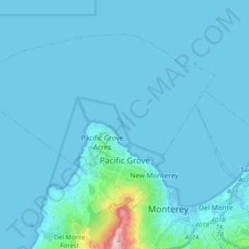
Nombre: Mapa topográfico Pacific Grove, altitud, relieve.
Altitud media: 14 m
Altitud mínima: -7 m
Altitud máxima: 246 m
Gracias por apoyar a este sitio ❤️
Haz una donación
Haz una donación
Otros mapas topográficos
Haga clic en un mapa para ver su topografía, su altitud y su relieve.
Prunedale
United States > California > Monterey County
Prunedale is a census-designated place in Monterey County, California, United States. It is located 8 miles (13 km) north of Salinas at an elevation of 92 feet (28 m). The population was 18,885 as of the 2020 census, up from 17,560 in 2010. Plum trees were grown in Prunedale in the early days of its founding,…
Altitud media: 69 m