
Mapa topográfico Kings Peak
Mapa interactivo
Haga clic en el mapa para ver la altitud.
Acerca de este mapa
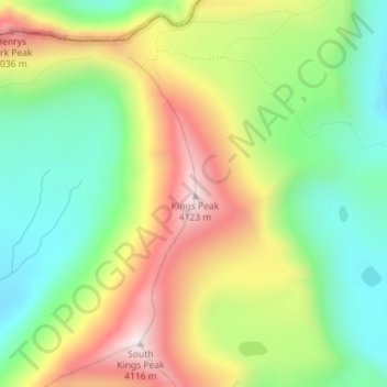
Nombre: Mapa topográfico Kings Peak, altitud, relieve.
Lugar: Kings Peak, Duchesne County, Utah, United States (40.77619 -110.37285 40.77629 -110.37275)
Altitud media: 3.743 m
Altitud mínima: 3.469 m
Altitud máxima: 4.118 m
Kings Peak is the highest peak in the U.S. state of Utah, with an elevation of 13,528 feet (4,123 m) NAVD 88.
Otros mapas topográficos
Haga clic en un mapa para ver su topografía, su altitud y su relieve.
Fruitland
United States > Utah > Duchesne County
Fruitland, Duchesne County, Utah, 84027, United States
Altitud media: 2.028 m
Starvation State Park
United States > Utah > Duchesne County
Starvation State Park, Duchesne County, Utah, United States
Altitud media: 1.786 m
Roosevelt
United States > Utah > Duchesne County
Roosevelt, Duchesne County, Utah, 84066, United States
Altitud media: 1.553 m
High Uintas Wilderness
United States > Utah > Duchesne County
High Uintas Wilderness, Duchesne County, Utah, United States
Altitud media: 2.919 m