
Haz una donación
Mapa topográfico Kelso
Haga clic en el mapa para ver la altitud.
Haz una donación
Acerca de este mapa
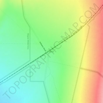
Nombre: Mapa topográfico Kelso, altitud, relieve.
Lugar: Kelso, San Bernardino County, California, United States (34.99176 -115.67154 35.03176 -115.63154)
Altitud media: 660 m
Altitud mínima: 616 m
Altitud máxima: 720 m
Haz una donación
Otros mapas topográficos
Haga clic en un mapa para ver su topografía, su altitud y su relieve.
Big Bear Lake
United States > California > San Bernardino County
Since 1970, Big Bear Lake has held an annual Oktoberfest. The Big Bear Lake Oktoberfest sports the highest beer garden, by elevation, in the United States. Big Bear Lake was incorporated as a city on November 28, 1980.
Altitud media: 2.189 m
Chino Hills
United States > California > San Bernardino County
Due to its topography of rolling hills, Chino Hills was primarily rural prior to the mid-1970s; most land was utilized for equestrian purposes and for dairies, except for the multi-use purposes of the State of California, promoting jobs for the community through day labor from the Chino Institute for Men on…
Altitud media: 255 m