
Haz una donación
Mapa topográfico Chino Hills
Haga clic en el mapa para ver la altitud.
Haz una donación
Chino Hills
Due to its topography of rolling hills, Chino Hills was primarily rural prior to the mid-1970s; most land was utilized for equestrian purposes and for dairies, except for the multi-use purposes of the State of California, promoting jobs for the community through day labor from the Chino Institute for Men on Central Avenue. Rapid and extensive housing developments followed throughout the 1980s and early 1990s, only slowing down in recent years. Most neighborhoods are arranged in a village-type format with strategically placed shopping centers and parks designed to be within walking distance of nearby homes.
Haz una donación
Acerca de este mapa
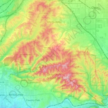
Nombre: Mapa topográfico Chino Hills, altitud, relieve.
Altitud media: 255 m
Altitud mínima: 75 m
Altitud máxima: 533 m
Haz una donación
Otros mapas topográficos
Haga clic en un mapa para ver su topografía, su altitud y su relieve.
Arrowhead
United States > California > San Bernardino County > San Bernardino > Arrowhead
Altitud media: 383 m