
Gracias por apoyar a este sitio ❤️
Haz una donación
Haz una donación
Mapa topográfico Proctor
Haga clic en el mapa para ver la altitud.
Gracias por apoyar a este sitio ❤️
Haz una donación
Haz una donación
Proctor
Proctor is adjacent to Duluth's Bayview Heights neighborhood, with which it forms something of a contiguous community unit due to Bayview Heights' topographical separation (the hill) from adjacent West Duluth. It is bounded by the city of Hermantown to the north, Midway Township to the west, Bayview Heights to the east, and a mostly undeveloped area of Duluth (officially in the Riverside neighborhood) to the south.
Gracias por apoyar a este sitio ❤️
Haz una donación
Haz una donación
Acerca de este mapa
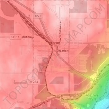
Nombre: Mapa topográfico Proctor, altitud, relieve.
Lugar: Proctor, Saint Louis County, Minnesota, United States (46.72054 -92.23955 46.76425 -92.21687)
Altitud media: 374 m
Altitud mínima: 194 m
Altitud máxima: 424 m
Gracias por apoyar a este sitio ❤️
Haz una donación
Haz una donación
Otros mapas topográficos
Haga clic en un mapa para ver su topografía, su altitud y su relieve.
Gracias por apoyar a este sitio ❤️
Haz una donación
Haz una donación
Gracias por apoyar a este sitio ❤️
Haz una donación
Haz una donación
Gracias por apoyar a este sitio ❤️
Haz una donación
Haz una donación
Gracias por apoyar a este sitio ❤️
Haz una donación
Haz una donación
Gracias por apoyar a este sitio ❤️
Haz una donación
Haz una donación